Background
Shared dockless e-scooters became a fixture of urban mobility within a few years — but how the built environment, and cycling infrastructure especially, shapes the way people actually ride and park them is still an open question. This MSc thesis investigated that relationship in Tel Aviv-Yafo using roughly 1 million trips and 2 million vehicle status transitions recorded in July 2023, asking whether riders take the shortest route home or go out of their way to stay near bike lanes — and whether that preference shows up in parking and demand patterns too.
Maps — Chosen Route vs. Shortest Path
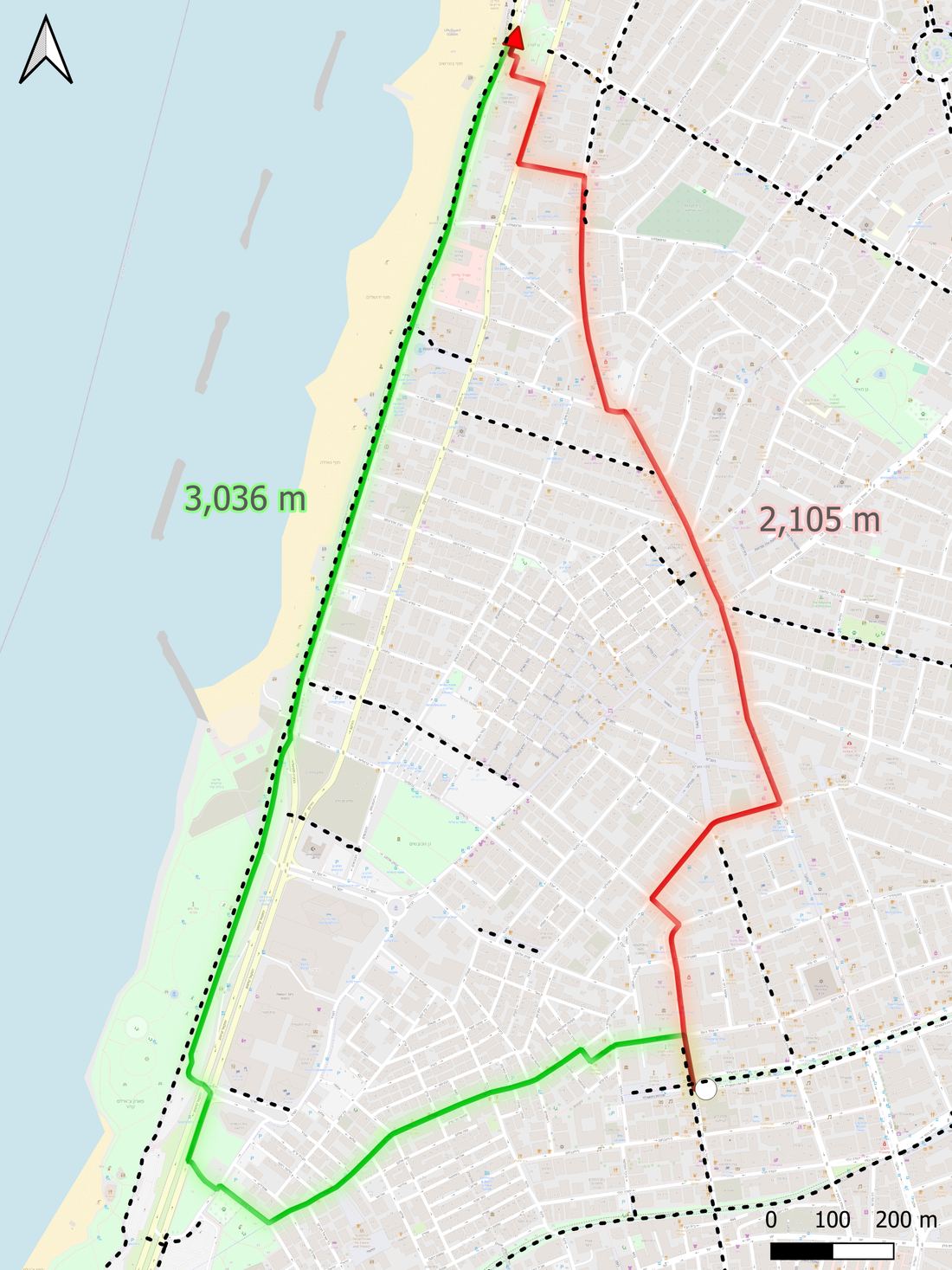
A rider heading south chose a 3,036m route along the coastal cycling lane (green, dotted = bike lanes) over a 2,105m shortest path (red) — adding roughly 45% extra distance to stay on the dedicated lane.
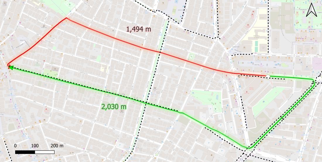
A second example: the chosen route (green, 2,030m) tracks a bike lane axis for most of its length, while the shortest path (red, 1,494m) cuts directly through the street grid.
Methodology
- Cleaned and prepared two raw MDS-format datasets — anonymised trip records and vehicle status-change logs — sourced from operators' shared-mobility feeds.
- Map-matched each recorded route onto the OpenStreetMap network with OSMnx and computed its shortest-path alternative, measuring exactly how much (and where) riders deviated from the most direct way.
- Overlaid the city's ~175 km of mapped bike lanes onto both chosen and shortest-path routes to test whether riders' actual paths ran along cycling infrastructure more than the optimal path would.
- Spatially joined vehicle parking events to the bike-lane network, neighbourhoods and traffic zones with GeoPandas, then ran statistical tests to check whether supply and demand cluster near cycling infrastructure more than chance would predict.
Results
Riders extended their routes by about 9% beyond the shortest path on average — and longer trips saw bigger detours. Chosen routes consistently carried a higher share of cycling infrastructure than the shortest-path alternative would, and parking events clustered near bike lanes at roughly twice the rate random chance would produce. A closer look showed that how well a bike lane connects to a destination matters: well-connected lanes drew tight vehicle clusters, while harder-to-reach lanes saw riders peel off toward the destination itself.
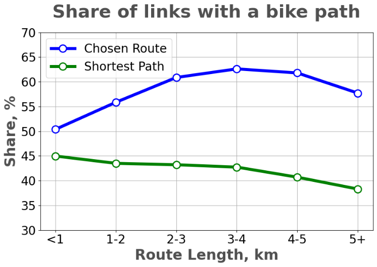
Across every route-length band, the chosen route (blue) ran along bike-path links far more often than the shortest-path alternative (green) would — a gap of roughly 12–19 percentage points that widens with trip length.
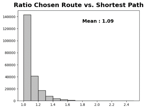
Distribution of chosen-route length divided by shortest-path length: the vast majority of trips cluster just above a ratio of 1.0, with a mean of 1.09 — the numerical backbone of the "~9% longer than necessary" finding above.
Thesis Document
The full thesis — including the complete literature review, methodology, data tables and discussion — is available to download below.
Download Thesis (PDF)